

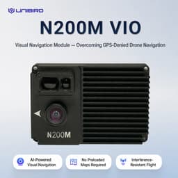

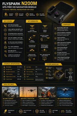


FlySpark N200M GPS-Free VIO module gives UAVs visual-inertial navigation, stable hover, takeoff and route support without GPS signals.
Orders are confirmed by our sales desk on WhatsApp. Reply usually within 1 hour (IST).
QtyMilitary-grade quality assured
Export-compliant documentation
24/7 engineering support
Talk to sales
Mon – Sun · 19:30 – 03:30 IST · [email protected]
Key facts
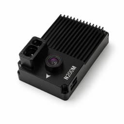
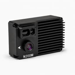
The FlySpark N200M is a visual-inertial odometry (VIO) navigation module for drones that need to hover, take off, land and follow routes when GPS/GNSS is unavailable or unreliable. It fuses a downward camera view of ground texture with inertial data and laser or LiDAR height, needs no preloaded maps, and outputs navigation data over MAVLink to PX4 or ArduPilot (APM) flight controllers. FlySpark lists a 30–200 m operating altitude, up to 15 m/s flight speed, 30 Hz output, 12 V / 7 W power and a 128 g weight, at ₹1,98,000.
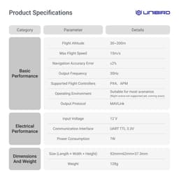
| Navigation method | Visual-inertial odometry (camera + IMU + laser/LiDAR height) |
|---|---|
| Recommended flight altitude | 30–200 m |
| Maximum flight speed | 15 m/s |
| Output frequency | 30 Hz |
| Navigation accuracy | ≤5% (listed) |
| Output protocol | MAVLink |
| Supported flight controllers | PX4 / APM (ArduPilot) |
| Communication interface | UART, TTL 3.3 V |
| Input voltage | 12 V (regulated) |
| Power consumption | 7 W |
| Dimensions | 92 × 62 × 37.3 mm |
| Weight | 128 g |
| Night operation | Not supported yet; daylight / visible-scene use recommended |
| Price | ₹1,98,000 (excl. GST), standard unit |
Sources: FlySpark catalog data (product description and specifications); MAVLink developer guide; PX4 user guide; ArduPilot Copter documentation. Updated .
Intelligence Brief
The FlySpark N200M GPS-Free VIO Navigation Module is an AI visual-inertial navigation system designed for UAVs, FPV drones, industrial drones and R&D platforms that need stable navigation when GPS/GNSS is unavailable, jammed, spoofed, blocked or unreliable. Using Visual-Inertial Odometry, the module combines downward visual sensing, IMU-based motion data, flight-controller attitude data and laser ranging to estimate drone motion and maintain positioning without depending on satellite signals.
N200M is built for GPS-free takeoff, landing, stable hover, route following and navigation support in unfamiliar environments without preloaded maps. It analyzes visual frame changes and ground texture in real time, fuses inertial data and outputs navigation information through MAVLink for compatible PX4 / APM flight controllers.
The module supports 30m–200m flight altitude, up to 15m/s flight speed, 30Hz output frequency, ≤5% listed navigation accuracy, UART TTL 3.3V communication, 12V input, 7W power consumption, 92mm × 62mm × 37.3mm dimensions and 128g weight. It is suitable for professional UAV integration where reliable GPS-free hover, visual positioning and navigation resilience are required.
IMPORTANT USE NOTE: This is a drone navigation component intended for lawful UAV operation, professional integration, R&D, inspection, security, industrial and authorized defense use. It must not be used for unlawful surveillance, unsafe autonomous operation, weaponization, privacy violation or aviation-rule violations. Drone operation must follow DGCA/local aviation rules, site permissions, privacy regulations, RF regulations and safe operator procedures. Performance depends on ground texture, lighting, altitude, vibration, flight speed, camera visibility, calibration and flight-controller integration.
Mission configurations
Select your operational configuration. Pricing may vary — request a formal quote for deployment quantities.
Standard FlySpark N200M GPS-free VIO navigation module for supported UAVs and FPV drone platforms requiring visual-inertial navigation in GNSS-denied or GPS-degraded environments. SKU: FSP-N200M-VIO-STD | Unit Price (excl. GST)₹1,98,00010 units | ||
Standard N200M module with PX4-focused wiring review, MAVLink port guidance, mounting guidance, flight-mode compatibility review and setup checklist. Recommended for PX4 drones, Pixhawk-class flight controllers and UAV R&D platforms. SKU: FSP-N200M-VIO-PX4 | Unit Price (excl. GST)POAAvailable | ||
Standard N200M module with APM / ArduPilot-style flight-controller integration review, UART/MAVLink connection guidance, mounting guidance and basic tuning checklist. SKU: FSP-N200M-VIO-APM | Unit Price (excl. GST)POAAvailable | ||
Standard N200M module with GPS-denied flight planning checklist, environment assessment, texture/lighting suitability review, mounting support and safe test-flight workflow. SKU: FSP-N200M-VIO-GPS-DENIED | Unit Price (excl. GST)POAAvailable | ||
Standard N200M module with inspection-drone integration support, stable-hover configuration checklist, vibration-control advice and site-use planning for powerline, refinery, bridge, mining and infrastructure inspection. SKU: FSP-N200M-VIO-INSPECTION | Unit Price (excl. GST)POAAvailable | ||
Standard N200M module with technical integration support, MAVLink workflow review, test-flight checklist, lab documentation and developer guidance for UAV labs and researchers. SKU: FSP-N200M-VIO-RD | Unit Price (excl. GST)POAAvailable | ||
Standard N200M module with operator orientation, installation review, performance-limit explanation, safe-use checklist, maintenance guidance and deployment SOP support. SKU: FSP-N200M-VIO-TRAINING | Unit Price (excl. GST)POAAvailable |
Active configuration
Standard FlySpark N200M GPS-free VIO navigation module for supported UAVs and FPV drone platforms requiring visual-inertial navigation in GNSS-denied or GPS-degraded environments.
₹1,98,000
Excl. GST
SKU: FSP-N200M-VIO-STD
Configuration matrix
Side-by-side specifications — click a column to select
| Parameter | |||||||
|---|---|---|---|---|---|---|---|
| Unit Price (excl. GST) | ₹1,98,000 | POA | POA | POA | POA | POA | POA |
| Stock | 10 units | Available | Available | Available | Available | Available | Available |
| SKU | FSP-N200M-VIO-STD | FSP-N200M-VIO-PX4 | FSP-N200M-VIO-APM | FSP-N200M-VIO-GPS-DENIED | FSP-N200M-VIO-INSPECTION | FSP-N200M-VIO-RD | FSP-N200M-VIO-TRAINING |
Technical Data Sheet
134 parameters across 16 categories
Complete specification index
Global export · local pricing
FlySpark exports this system worldwide with end-user certification, dual-use classification, and destination-specific compliance. Open your country edition for indicative local pricing; the binding quote is issued on WhatsApp in your currency.
All export marketschevron_right| Market | Indicative price | Quote |
|---|---|---|
| United States | US$2,190 | Quote for United States → |
| United Kingdom | £1,660 | Quote for United Kingdom → |
| Germany | 1.990 € | Quote for Germany → |
| France | 1 990 € | Quote for France → |
| Ukraine | 99 600 ₴ | Quote for Ukraine → |
| United Arab Emirates | AED 8,050 | Quote for United Arab Emirates → |
| Australia | A$3,250 | |
| Japan | ¥350,000 | |
| Brazil | R$ 12.500 | |
| Canada | CA$3,135 | |
| Turkey | ₺110.500 | |
| Poland | 8770 zł |
Same category
Related systems


